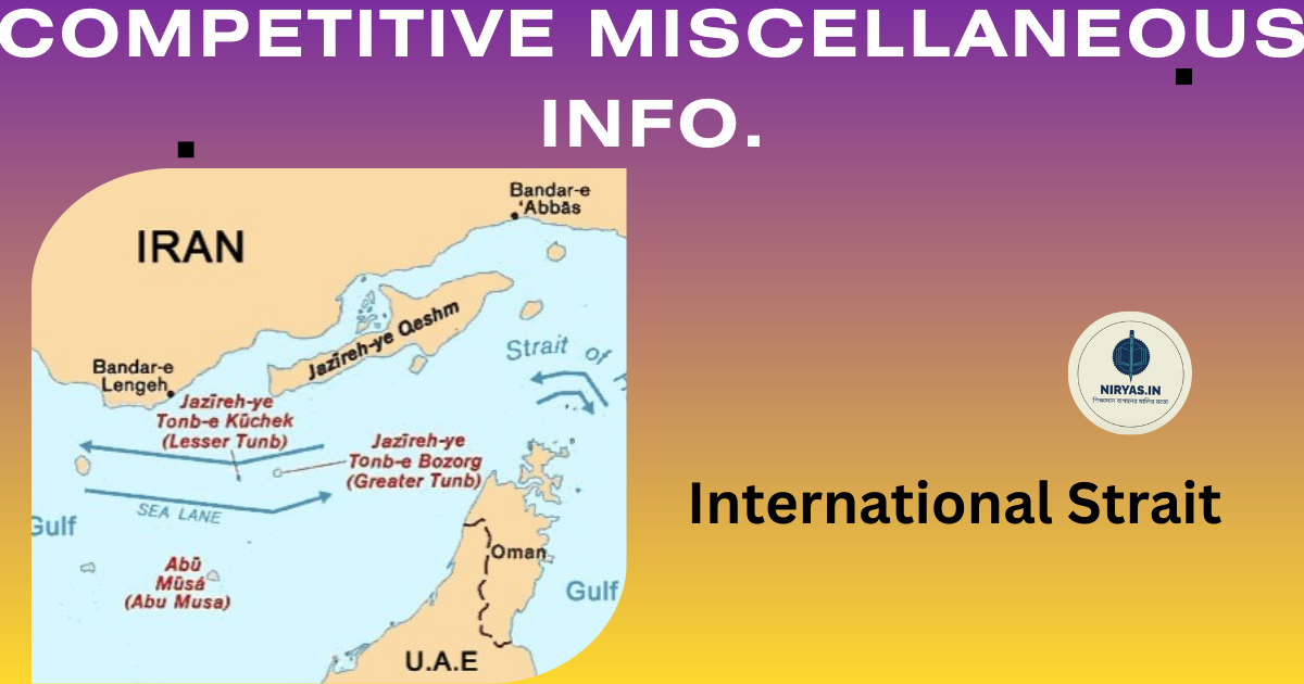
International Strait Part-2 in English
International Strait
It is normal for questions to come from general knowledge in important competitive examinations at all India or state level. Again, the scope of general knowledge is also wide. By studying the questions that come from different topics on Static GK, several specific topics will be discussed in detail. In this case, the topic under discussion is International Strait.
International Strait : Part-2
Bering Strait: The Bering Strait is a strait between the Chukchi Peninsula in the far east of Russia in Asia and the Seward Peninsula in Alaska in the east, connecting the Arctic Ocean in the north with the Pacific Ocean in the south. The narrowest part of the Bering Strait is between Cape Dezhnev on the Chukchi Peninsula in Russia and Cape Prince of Wallace on the Seward Peninsula in Alaska, North America, with a length of about 82 km, which is considered the shortest distance between the two continents of Asia and North America. The average depth of the strait is 83 km, the average depth of the strait is 50 m and the deepest part is 90 m. The International Date Line extends (imagined) along the middle of the strait. The strait is named after the Dutch explorer Vitus Jonassen Bering (August 16, 1728). International Strait
Strait of Gibraltar: The narrow body of water between the Iberian Peninsula in the southern part of the European continent, the western tip of Eurasia, Spain in Europe, and Morocco in the northern part of the African continent, i.e. the water separating Europe and Africa, is known as the Strait of Gibraltar, which connects the waters of the Atlantic in the west with the waters of the Mediterranean in the east. The word Gibraltar is derived from “Jabal al Tariq”, which means “Mountain of Tariq”, which is located in the southern tip of Spain. The distance between the European and African continents along this strait is only 13 km, which is the distance between Punta Marroquí in Spain and Point Cyrene in Morocco. The depth of the strait is 300-900 m.
Korea Strait: The Korea Strait is a strait between the Korean Peninsula in mainland Asia and the Kyushu Island in the southwestern part of Japan, which connects the Sea of Japan to the northeast and the Yellow Sea to the southwest. It is 200 km wide and has an average depth of 90-100 meters. The presence of Deimado Island in the middle of the strait divides the strait into two. The section of the strait between Deimado and South Korea is known as the West Channel, and the section between Deimado and Japan is known as the West Channel or Tsushima Channel. A part of the Kuroshio Current flows from west to east through this strait as a warm current, which is known as the Tsushima Current. International Strait
Strait of Malacca: The Strait of Malacca is a narrow body of water between Malaysia on the Malay Peninsula in Southeast Asia and the island of Sumatra in the Indonesian archipelago in the Indian Ocean, connecting the Pacific Ocean to the west. The strait is about 930 km long, 50–320 km wide, and has an average depth of 25 m.
Singapore Strait: The narrow body of water between the southern city of Singapore in Malaysia to the north and the city of Batam in the northern Riau Islands of Indonesia to the south, connecting the Strait of Malacca to the west with the South China Sea to the east. The strait is about 113 km long, 19 km wide, and has an average depth of 22 m.
Bonifacio Strait: The Bonifacio Strait is a strait between the French island of Corsica in the north and the Italian island of Sardinia in the south, connecting the Gulf of Sardinia in the Mediterranean Sea to the Tyrrhenian Sea in the east. The strait is about 11 km wide and has a maximum depth of 100 m.
Palk Strait: The strait is a strait between the southern part of the Indian state of Tamil Nadu and the northern part of the island nation of Sri Lanka, connecting the Bay of Bengal in the northeast with the Gulf of Palk in the southwest. It is named after Sir Robert Palk, the then Governor of the Madras Province of the British East India Company. The maximum and minimum widths of the strait are 82 km and 53 km respectively. The Ramayana-famous Rama Setu is located in the section of this strait between Dhanushkodi on Pamban or Rameshwar Island in the Indian state of Tamil Nadu and Mannar Island on the northwest coast of Sri Lanka. This bridge is also known as ‘Adam’s Bridge’, Nala Setu, Setu Bandhan etc. Dhanushkodi is the southernmost landmass of India in this section. International Strait
Bosphorus Strait: The Bosphorus Strait is a narrow strait in the western part of Turkey, between Eastern Thrace and mainland Turkey, which separates Europe and Asia, and connects the Black Sea to the northeast and the Sea of Marmara to the southwest. It is 31 km long, has an average depth of 1,000 m, and is 700–3,300 m wide.
Bass Strait: The Bass Strait is a strait between Victoria and Tasmania, located in the southeastern part of the Australian mainland, connecting the Indian Ocean to the west, the Great Australian Bight, and the Tasmanian Sea to the east. The strait is 500 km long, 300 km wide, and an average depth of 60 m. The Dutch explorer Abel Janszoon Tasman first discovered this strait. The strait is named after the British admiral and explorer of the Australian continent George Bass.
Davis Strait: The water between Greenland and Baffin Island in Nunavut, Canada’s northernmost and largest territory, is known as Davis Strait, which connects the Atlantic Ocean to the south with Baffin Bay to the north. The strait is named after the British navigator John Davis. Basically, this strait is a branch of the Atlantic Ocean that is located in the north through the Labrador Sea. This strait is about 650 km long from north to south and more than 300 km wide. Its depth is 100-2000 m. The deepest point of this strait is the eastern Arctic region (3660 m). International Strait
Windward Passage: The water section between the two island states of Cuba and Hispaniola, located at the junction of the Atlantic Ocean, the Caribbean Sea and the Gulf of Mexico, is known as the Windward Passage, which connects the Caribbean Sea to the east with the Atlantic Ocean. The maximum width of this strait is 80 km and the average depth is 1700 m.
Jamaica Channel: The water section between the two island states of Jamaica and Hispaniola, located at the junction of the Atlantic Ocean, the Caribbean Sea and the Gulf of Mexico, is known as the Jamaica Channel, which connects the Atlantic Ocean to the north and the Caribbean Sea to the south through the Windward Passage. The maximum width of this strait is 190 km and the average depth is 1200 m.
Hudson Strait: The body of water between Baffin Island in the north and the Canadian province of Quebec in the south is known as Hudson Strait, which connects Labrador Bay to the east with Hudson Bay to the west. The strait is 720 km long, and varies in width from 64 to 240 km. The British navigator Sir Martin Frobisher first identified this strait, and he mistakenly named the strait ‘Mistaken Strait’ because he entered this strait. Later, the strait was named after the British marine explorer Henry Hudson.
➣ বাংলায় পড়ুন ➣ हिंदी में पढ़ें
Discover more from NIRYAS.IN
Subscribe to get the latest posts sent to your email.


